top of page

Cartistic
Endeavors
Map Art for
the Home and Office
New For 2023
The East End
Long Island, N.Y.
circa 1850
20"w x 16"h

Map detail at 100%.
Go to our partners at
Fine Art America
to order this map.
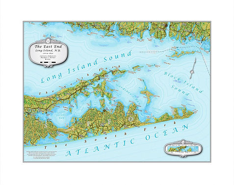
A mid-19th century period map of eastern Long Island depicted in our Historic Landscape Style (TM).
This full-color map covers both the North and South Forks, from Montauk and Orient Points to Riverhead.
It includes detailed shallows of the Shinnecock, Great and Little Peconic, and Gardiners Bays while reaching into Block and Long Island Sounds.
Get your own piece of history for your home or office today!
Long Island New York
and Vicinity
circa 1850
36"w x 11.75"h

Map detail at 100%.
Go to our partners at
Fine Art America
to order this map.
The Northern Outer Banks
of North Carolina
circa 1930
10"w x 20"h

Map detail at 100%.
Go to our partners at
Fine Art America
to order this map.
Cape Cod
and Vicinity
circa 1900
20"w x 16"h

Map detail at 100%.
Go to our partners at
Fine Art America
to order this map.

Hang this map on your wall and be transported back in time to when New York could fit onto Manhattan Island, Hempstead Plains was still agricultural, and the Pine Barrens seemed to stretch without end.
Captured in our Historical Landscape Style (TM) the U. S. Coast Surveys preliminary charts of the region are brought to life in exquisite detail and in full-color.
A beautiful piece of cartographic art to adorn any home or office.

Step back in time before the beach homes and tourist hoards descended on what used to be the backwater of the North Carolina Coast, known mostly to gun clubs and fishermen.
Rendered in our Historic Landscape Style (TM), the Outer Banks from the Virginia border to Kitty Hawk, from the shallows of Albemarle and Currituck Sounds, to the swamps of the mainland appear in glorious full-color and exquisite detail to transport you from your home or office to a time when fish were abundant and waterfowl filled the skies.
First of a 3-map series.

Encompassing the Cape as well as Martha's Vineyard and Nantucket Island, let our Historic Landscape Style (TM) transport you to a simpler time when fishermen ruled and sandy shores stretched clear
bottom of page